
INTERGEO 2026 Attendees List & Exhibitors List
Access a verified, campaign-ready database of surveyors, geospatial professionals, GIS specialists, civil engineers, urban planners, government authorities, infrastructure developers, construction companies, technology providers, geodata experts, and exhibitors participating in INTERGEO 2026 at Messe München, Munich, Germany.
With 18,500+ trade visitors, 530+ exhibitors, and participation from 119 countries, INTERGEO 2026 is the world’s leading trade fair and conference for geodesy, geoinformation, and land management. The event brings together industry leaders to showcase innovations in surveying, GIS, geospatial technologies, drones, remote sensing, BIM, digital twins, smart cities, and digital infrastructure.
Whether you’re looking to promote surveying equipment, GIS software, drone technologies, LiDAR solutions, mapping systems, engineering software, smart city platforms, digital construction technologies, or geospatial services, the ExpoLake INTERGEO 2026 Contact List provides verified, segmented business data to help your sales and marketing teams connect with qualified decision-makers before, during, and after the exhibition.
- 15–17 September 2026
- 18,000+ Attendees | 500+ Exhibitors
- Messe München, Munich, Germany
- IT & Technology
Get Your Contact List
18k+
Verified Attendees
500+
Exhibiting Companies
95%
Accuracy
24-72 hr
Delivery Time
5x
Verification Layers
INTERGEO 2026

The exhibition covers a broad range of technologies, including surveying equipment, GIS software, GNSS solutions, drones, remote sensing, LiDAR, BIM, digital twins, smart city technologies, and land management systems. With 530+ exhibitors, 18,500+ trade visitors, and participation from 119 countries, INTERGEO 2026 provides a premier platform for discovering cutting-edge geospatial solutions, building strategic partnerships, and connecting with decision-makers across the global surveying, mapping, and geoinformation industry.
Meet the Exhibitors at INTERGEO 2026
More than 530 exhibitors from across the global geospatial ecosystem exhibit at INTERGEO 2026, showcasing the latest innovations in surveying, GIS, geodata, digital twins, drones, smart cities, BIM, positioning technologies, and digital infrastructure solutions.
Surveying Equipment & Geodesy Solution Providers
Manufacturers of total stations, GNSS/GPS systems, laser scanners, precision measuring instruments, surveying equipment, and positioning technologies for land surveying and engineering applications.
GIS, Geospatial & Mapping Software Companies
Developers of GIS platforms, mapping software, spatial analytics tools, geodata management systems, cloud-based geospatial applications, and location intelligence solutions.
Drone, LiDAR & Remote Sensing Technology Providers
Companies specializing in UAVs, drone mapping, LiDAR systems, photogrammetry software, aerial imaging, satellite technologies, and remote sensing solutions.
BIM, Digital Twin & Smart City Solution Providers
Suppliers of Building Information Modeling (BIM) software, digital twin platforms, smart city technologies, infrastructure management systems, and digital construction solutions.
Engineering, Construction & Land Management Companies
Providers of civil engineering software, cadastral systems, land administration platforms, infrastructure planning tools, utility mapping solutions, and asset management technologies.
Geospatial Data, AI & Technology Service Providers
Organizations offering geospatial consulting, AI-powered spatial analytics, earth observation services, environmental monitoring, location intelligence, digital transformation, and enterprise geodata solutions.
Discover Who Attends INTERGEO 2026
Surveyors & Geospatial Professionals
Licensed surveyors, geodesists, geomatics engineers, mapping specialists, and land surveying professionals seeking the latest surveying equipment, positioning technologies, and geospatial innovations.
GIS, Mapping & Spatial Data Specialists
GIS analysts, cartographers, geoinformation experts, spatial data managers, remote sensing professionals, and location intelligence specialists exploring advanced geospatial software and analytics solutions.
Civil Engineering, Construction & Infrastructure Professionals
Civil engineers, construction managers, project developers, architects, BIM specialists, and infrastructure planners evaluating digital construction, digital twin, and engineering technologies.
Government Authorities & Land Management Officials
Representatives from municipalities, cadastral agencies, land administration departments, transportation authorities, environmental agencies, and public sector organizations managing geospatial and infrastructure projects.
Smart City, Utility & Digital Transformation Leaders
Smart city planners, utility managers, digital transformation executives, asset management professionals, IoT specialists, and technology decision-makers implementing connected infrastructure solutions.
Technology Providers, Consultants & Researchers
Software developers, geospatial consultants, system integrators, drone specialists, satellite technology experts, AI professionals, academic researchers, and industry consultants driving innovation across the geospatial ecosystem.
Explore the INTERGEO 2026 Contact Database
The INTERGEO 2026 Attendees & Exhibitors List includes 20+ verified contact and firmographic data fields, enabling highly targeted outreach to surveyors, GIS professionals, geospatial technology providers, engineering firms, government agencies, infrastructure companies, and smart city decision-makers.
Each record provides essential business and contact information to help your sales and marketing teams identify qualified prospects and execute personalized B2B campaigns across the global geospatial industry.
Core Data Fields in Our INTERGEO 2026 Email List
- Full Name
- Job Title
- Verified Business Email Address
- Direct Phone Number (where available)
- Company Name
- Company Website
- Organization Type
- Business Category
- Seniority Level
These structured data fields enable you to segment contacts by organization type, job role, seniority, geography, company size, and geospatial specialization, helping you maximize the effectiveness of your B2B marketing campaigns before, during, and after INTERGEO 2026.
Data Fields Included
20+ FieldsRefine Your INTERGEO 2026 Attendees & Exhibitors List
Why ExpoLake Is Your Trusted Source for INTERGEO 2026 Contacts
Reach Global Geospatial Decision-Makers
Connect with verified surveyors, GIS professionals, geospatial engineers, government officials, infrastructure planners, technology providers, and business leaders participating in INTERGEO 2026.
95% Verified Data Accuracy
Every contact is verified through email validation, domain checks, and professional profile verification to maintain up to 95% data accuracy. Invalid records are replaced at no additional cost.
Ready for Multi-Channel Marketing
Launch targeted email campaigns, LinkedIn outreach, appointment scheduling, account-based marketing (ABM), and post-event follow-ups using CRM-ready contact data.
Comprehensive Business Intelligence
Each record includes verified contact details, job title, organization type, seniority, company information, industry segment, and business insights for highly personalized outreach.
Advanced Audience Segmentation
Filter prospects by organization type, geospatial specialty, job function, seniority, company size, revenue, location, attendee or exhibitor status, and technology category for more effective campaigns.
Fast, Compliant Delivery
Our data is sourced using consent-first practices aligned with GDPR, CAN-SPAM, and CASL, with delivery in Excel or CSV format within 2–4 business days.
Looking for Past or Upcoming Event Editions?
Get verified attendee and exhibitor contact lists from past and upcoming event editions worldwide. ExpoLake delivers accurate, segmented B2B contact data covering key decision-makers and exhibiting companies, so your outreach always reaches the right person at the right time.
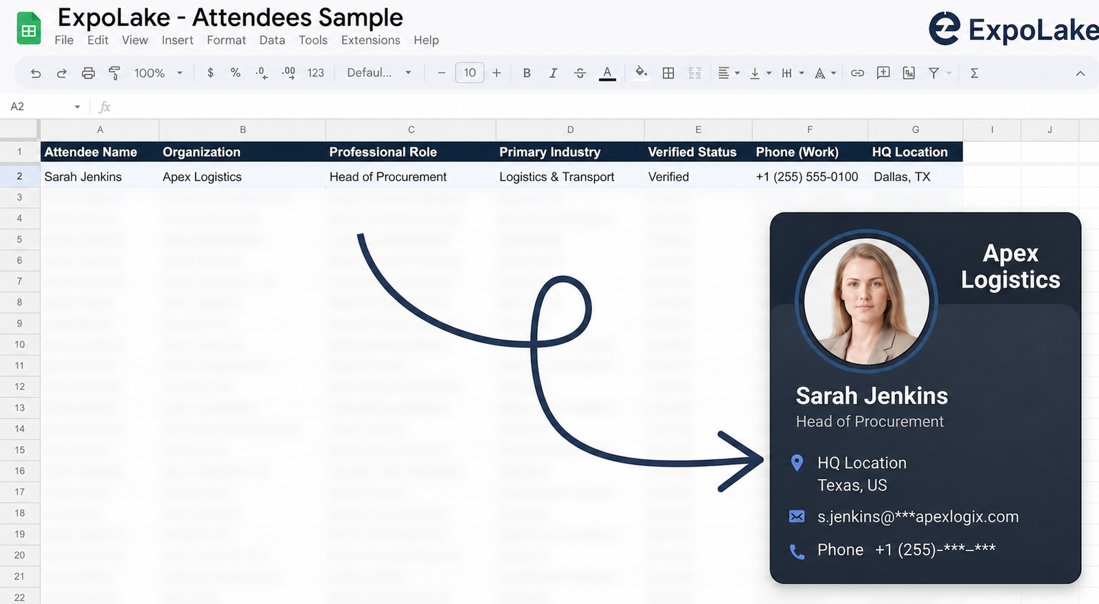
Explore a Sample of Our INTERGEO 2026 Attendees & Exhibitors Database
Request a complimentary sample of the ExpoLake INTERGEO 2026 Attendees & Exhibitors List before making your purchase.
Preview verified contacts of surveyors, GIS professionals, geospatial engineers, government agencies, infrastructure planners, technology providers, and industry decision-makers participating in INTERGEO 2026. Our CRM-ready database is optimized for email marketing, LinkedIn outreach, appointment setting, lead generation, and B2B sales campaigns.
Evaluate the quality and accuracy of our verified business data before choosing a customized contact list that fits your marketing goals.
Key Benefits of the INTERGEO 2026 Email Database
Connect with Qualified Geospatial Buyers
Reach verified surveyors, GIS professionals, geospatial engineers, government agencies, infrastructure planners, and technology decision-makers actively seeking innovative geospatial solutions.
Launch Campaigns Before INTERGEO 2026 Opens
Schedule meetings, introduce your solutions, and engage qualified prospects before the exhibition begins to maximize networking opportunities.
Accelerate Your Sales Pipeline
Connect with attendees actively evaluating surveying equipment, GIS software, drone technologies, mapping solutions, and digital infrastructure platforms.
Expand Across the Global Geospatial Market
Build relationships with professionals from surveying firms, engineering companies, government organizations, construction businesses, and technology providers from 119 countries.
Strengthen Post-Event Engagement
Follow up with verified attendees and exhibitors after the event to nurture leads, build long-term relationships, and increase conversion opportunities.
Maximize Your Event ROI
Support your exhibiting, sponsorship, and marketing efforts with verified attendee and exhibitor data for effective pre-event, onsite, and post-event campaigns.
Similar Events Datasets
Browse Event Attendees Data By Country







How ExpoLake Builds Verified Event Contact Data
Every contact in the ExpoLake database goes through a structured, multi-step sourcing and verification process before it reaches your team. Here is how we build data you can trust.
Multi-Source Data Harvesting
Contacts are gathered from trade shows, global directories, e-books, newsletters, and digital publications spanning dozens of industries and regions.
AI-Powered Enrichment
Machine learning fills missing fields, appends firmographic data, and segments contacts by industry, role, company size, and intent signals — automatically.
Cross-Platform Verification
Every record is cross-checked against our master database and validated via social platforms, public registries, and news sources to confirm authenticity.
Statistical Cleansing
Anomalies, duplicates, and stale entries are flagged using statistical models and eliminated. A final manual audit ensures the highest standard of data quality.
Consent Campaign
A/B-tested opt-in email sequences are deployed to capture and confirm explicit consent, fully aligned with GDPR, CAN-SPAM, and CASL compliance frameworks.
Tele-Verification & Delivery
A final tele-verification call confirms all data fields. Only fully validated, consented records are released to the client — clean, compliant, and ready to use.
What Our Clients Say




Connect with the Right People, at the Right Time
Frequently Asked Questions (FAQ's)
What does the INTERGEO 2026 Attendees & Exhibitors List include?
The database includes verified contact details such as full name, job title, business email, phone number (where available), company name, website, location, LinkedIn profile, organization type, and attendee or exhibitor status.
Who can benefit from the INTERGEO 2026 contact database?
The database is ideal for surveying equipment manufacturers, GIS software providers, drone companies, engineering firms, smart city solution providers, mapping technology vendors, and B2B marketers targeting the geospatial industry.
Can I request a customized INTERGEO 2026 contact list?
Yes. We can customize your database based on geography, company size, revenue, industry, job title, technology specialization, attendee type, and other business criteria.
Is the INTERGEO 2026 database suitable for lead generation?
Absolutely. The database is designed to support lead generation, appointment setting, email marketing, LinkedIn outreach, ABM campaigns, and post-event follow-up activities.
In which format is the INTERGEO 2026 database delivered?
The database is delivered in Excel or CSV format, making it easy to import into CRM systems and marketing automation platforms.
How often is the INTERGEO 2026 contact database verified?
Each database undergoes multiple quality checks, including email validation and profile verification, to help maintain high data accuracy before delivery.
Can I receive a sample before purchasing the INTERGEO 2026 database?
Yes. We provide a complimentary sample so you can review the data quality, available fields, and overall structure before placing your order.